In last week’s design journal, Character Rolls & Skill Advancement we talked broadly about the four different character roles, the different skill trees - including the Survival and Bardic trees, and how skill advancement works.
In this week's design journal we're going to delve more deeply into the Explorer role with a look at two of the most compelling and innovative skills found in Chronicles of Elyria. In particular, we're going to talk about Maps, Cartography (the Bardic skill used to make maps), and Navigation (the Survival skill used to, among other things, read maps).
Maps
Maps in Chronicles of Elyria are small, stackable objects which sit in your inventory like any other item. They can be bought, sold, traded, destroyed, stolen, and like most other items in the world - crafted.
Unlike in many other MMOs, if you don't have a map on your person you have no way of pinpointing your precise location. Even with a map it takes a skilled navigator and a high quality map to know your exact location. Of course, if you're moving around in areas you're already familiar with there's no need to look at your map.
The Map View
When looking at your map you'll transition to a first-person perspective and view your map as though through the eyes of your character. Unlike in other MMOs there is no user interface that shows the map and it's rather impractical to look at your map while moving. Not least of which because having your map in your hands means you don't have your weapons. Encounter anything dangerous and you'll have to drop your map or stow it in your backpack before engaging the enemy.
 Figure 1 – Early in-game shot of a player-drawn world map.
Maps and Families
As mentioned back in Design Journal 5 Families & Family Selection, your family is your support system in the world and are responsible for helping you learn your way about. One of the things that helps the most is having information about where you live, dangerous locations near your home, where shops are, where the nearest major towns are, etc...
To help make sure this happens, maps are tightly integrated into the family creation process. Whenever you go through the process of creating children, the parents are required to provide a sort of care package for their offspring. This includes a basic set of clothing, a set of tools for the family's primary occupation (which could very well be a sword), as well as a set of maps. I say 'set', because you'll need to provide more than one.
Map Scale
Chronicles of Elyria provides a few different scales with respect to maps. These scales identify how much land is covered by the map, as well as what objects can appear on the map. Maps in CoE are roughly divided up into 8 scales, which are, in order of increasing size:
- Structural
- Settlement
- Regional
- County
- Duchy
- Kingdom
- Continent
- World
Structural maps represent the smallest scale and can be used for mapping castles, ruins, dungeons, and underground caverns. Objects on a structural map will typically be the location of different rooms and hallways, where any items or traps are, and the location of any creatures. It's important to note that, in the case of monsters at least, they may roam and aren’t guaranteed to be where you left them.
Settlement maps represent the second smallest scale. Objects on a settlement map will generally be buildings, farms, the location of important crafting resources, etc... In short, it helps you learn your way around a settlement.
Regional maps are typically larger than a settlement map and more detailed than a county map. Examples of objects on a regional map might be the location of an unknown species of tree in a nearby forest, or the spawning grounds for a den of dire wolves. In general, regional maps are used by Explorers and Gatherers to communicate information about resources in the wild.
County maps are scaled to roughly the size of an average county and are used to indicate the relative position of major landmarks. These can be the location of settlements such as hamlets, villages, and towns, geographical landmarks such as rivers, lakes, forests, and trade routes, and can include large resource locations such as an established mine or quarry.
Duchy maps are perhaps the least common map type and show county borders and positions of large geographical structures such as mountains, valleys, massive lakes, beaches, forests, and watersheds. They also show towns, cities, the most important resources gathering areas, and trade routes between the counties, or in and out of the duchy.
Kingdom, continent, and World maps are the most expansive and are designed to show duchy and kingdom boundaries, major cities, and principal trade routes in-between duchies and kingdoms. World maps are largely decorative items, used only to express the scope of the known world. Continent and kingdom maps are primarily used by kings and nobles to track diplomatic boundaries.
Object Permanence
While maps can be edited, they do get stale. Because the world keeps on living after a map is made, it should be understood that a map doesn’t necessarily reflect reality. In specific, a map can be different from reality because:
- Things now exist that did not exist at the time the map was made
- Things no longer exist which existed when the map was made
- The cartographer only illustrated a subset of the total relevant data
- The cartographer fabricated information for their own self-interest
This means there can be things in the world that don't appear on a map, and things on a map that don’t exist in the world. Buyer beware!
Cartography
As mentioned in the first part of the journal, unlike in other MMOs, maps in Chronicles of Elyria are player-created. While the game will ship with a partial set of maps for different areas of the world, they'll be relatively low quality, fairly inaccurate, and without a lot of detail. It'll be up to players - Explorers and Champions in particular, to go out into the world and bring back maps of different regions and the location of important resources
Creating Maps
The process of creating maps in CoE is a lot like creating maps in real life. When you sit down to create a map you'll be presented with ink, parchment, and a series of tools to help you make the map. The first thing you'll need to decide is what scale of map you're working with. This is important because the types of tools you use will depend upon the scale of the map you want to draw.
For example, if you're looking to draw a structural map, you'll need to pull out the tools for drawing structures. This'll include tools for measuring and drawing rectangular and circular rooms of different sizes, as well as stamps that indicate where things are located in the dungeon.
If you're looking to draw a regional map, then you'll want to pull out the regional tools. These will include stamps for things like mountains and forests, as well as spline tools to help you draw rivers, lakes, and roads. Of course, it's not all about utility. The stamp tools like mountains and forests randomly cycle through sets of stored images. So as you cover your maps in patches of trees, it'll ensure it looks aesthetically pleasing.
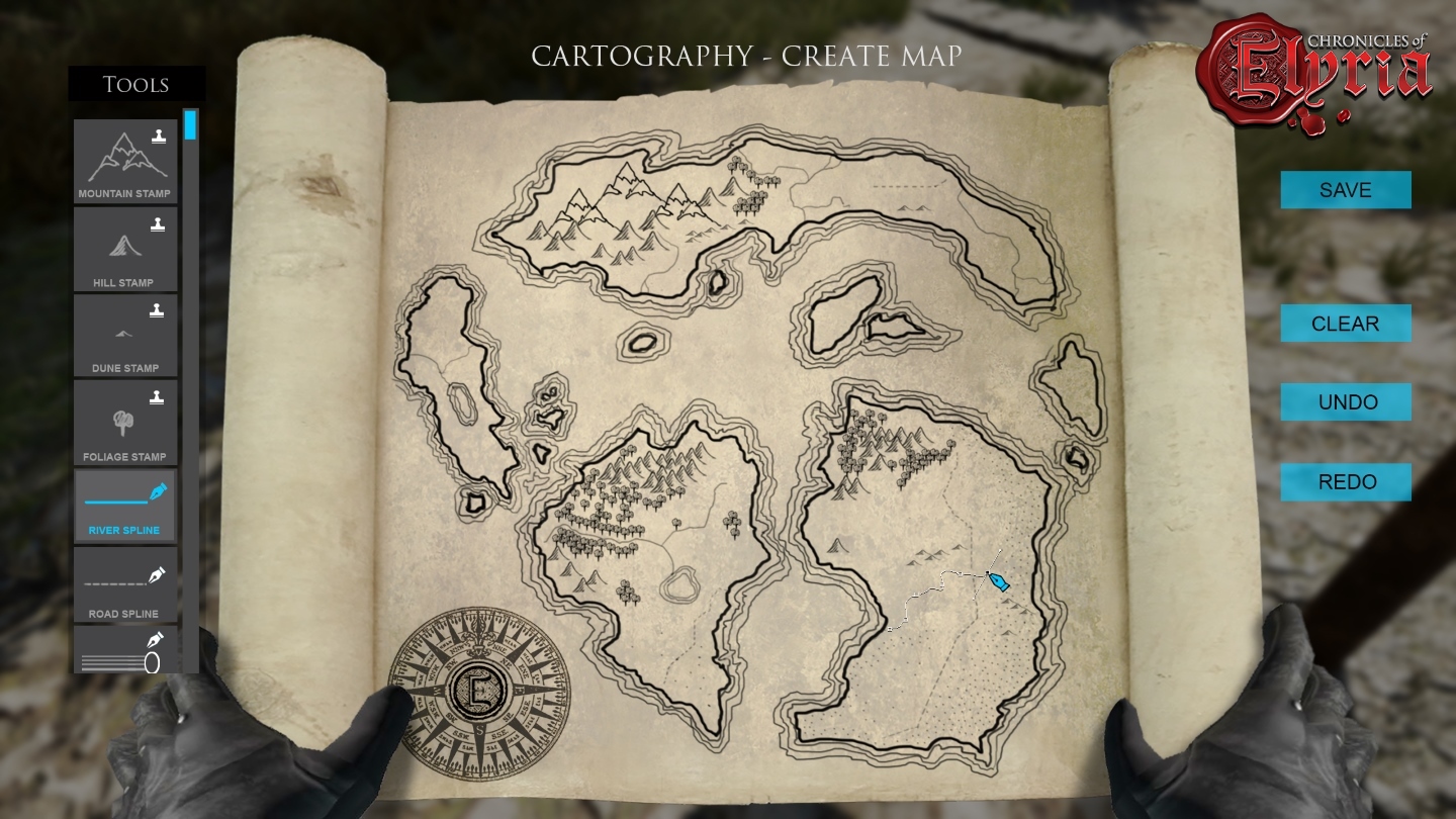 Figure 2 – Early in-game view of map-making.
The Power of Names
When creating a map, the cartographer has the ability to select regions that he/she has identified on the map and give those regions a name. This is true for forests, mountain ranges, villages, mines, etc... If something can be stamped, drawn, or enclosed on the map it can be given a name.
Why is this such a powerful feature? Because the Soulborn Engine keeps track of all the names given to a town, village, watershed, lake, Kingdom, etc... And whichever name appears most frequently on maps for that landmark, that's the name that it will be referred to by NPCs and by recent in-game lore.
This has two powerful implications. First, it means that even after a kingdom has been sacked and the new King has changed its name, the region will continue to be commonly referred to by the old name until the new King has actively attempted to destroy existing maps of the region, and paid a healthy sum to cartographers to create and distribute enough new maps as to officially change the name.
Second, this means it won't be uncommon to come across older maps - settlement, regional, or even structural maps, which refer to places that no longer exist. Long lost civilizations from a thousand years before may still be referenced in hidden archives. It may be worthwhile to the aspiring Explorer or Champion to research books in the library and discovered tombs to try and reconcile the new location of ancient places. Doing so could prove both extremely profitable and decidedly dangerous.
A final note on the naming of landmarks. Writing on the map can be in any language the cartographer is sufficiently skilled in. So in addition to finding maps which reference places that no longer exist, you may find maps with writing on them that you can't read.
Navigation
The final part of this week's design journal brings it all together. While maps tell you what the world looks like, and cartographers are able to create maps, it's a player's Navigation skills that allows them to use maps, and other tools, to find their place in the world.
Whether navigating during the day or night, the first fundamental task of navigation is identifying which way is north. If it's daytime, and you're both lucky and skilled enough to have a compass, you can simply check your compass to identify which way is north. If you're not, you'll need to use the position of the sun.
Once you've done that, you can position your body in such a way that checking a sundial for the time of day (See Figure 3), or reading your map becomes possible. While oriented north, you can identify on your map the object that is closest in front of you, to the right of you, behind you, and to the left of you. Doing so will position your character's cursor on the map. The more accurate the map, and the higher your navigation skill, the more accurate your character position will be.
Putting your map away causes your player marker to vanish and you'll have to go through the process again in order to re-plot your position.
If it is night time all of the above still applies, except you'll need to use astronomy rather than the position of the sun to identify true North. While more challenging, it’s still possible to identify your position, direction, and time of night simply by looking at a clear sky.
 Figure 3 – Checking your sundial to determine the time of day.
Sensory Maps (formerly known as Mini-maps)
The last topic I wanted to touch on was mini-maps. As a survival game, and one that tries to keep the user interface free of clutter, there remains an ongoing debate about whether or not to include a mini-map and what its true purpose is.
We are currently including a mini-map, however, it doesn’t serve the same purpose as usual. Instead, it serves as a survival tool and is tied to your character's senses. If your character hears (or smells) something in the bushes, regardless of whether you as a player heard or smelled it (maybe you're deaf, maybe you had your sound turned off, maybe you've realized you can't smell things in your game) there will be a visible indicator on your sensory-map. This allows us to leverage both player senses as well as character senses and creates a tighter bond between you and your character.
What's next?
That's all for this week. Next week we put the parchment and plume aside and look at the other stuff your character can carry. In the next design journal we'll take an in-depth look at Inventory and Equipment.

